
22 October 2024
48470
2024-10-22 11:13
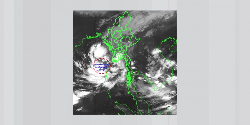
According to the observations at (5:30) AM Myanmar Standard Timetoday on Tuesday, the well-markedlow-pressure area over East-Central Bay of Bangel has moved northwest still persists.
It is likely to move West-Northwestwards and may intensify into a Depression during next (12) hours and into a Cyclonic storm over East central Bay around 23rd October 2024 and may reach to Northwest Bay of Bengal (off Odisha-West Bengal Coasts, India).
Thereafter, it is likely to move northwestwards and intensify into a severe Cyclonic Strom and may cross north Odisha and West Bengal coasts between Puri and Sagar Island in early morning 25th October 2024.Due to the Well-MarkedLow-Pressure Area, rain or thundershowers are likely to be fairly widespread to widespread in Naypyitaw, Sagaing. Mandalay, Magway, Bago, Yangon, Ayeyarwady, Taninthayi Regions and Chin, Rakhine, Kayin, Mon States with likelihood of regionally heavy falls, isolated heavy falls and strong winds from the morning of 22ndup to 24th, October 2024.
Occasional squalls with rough seas will be experienced off and along Myanmar Coasts. Surface wind speed in squalls may reach 50-55 m.p.h. Wave height will be about 9-14 feet off and along Myanmar Coasts.People should be aware the natural disasters such as the heavy rainfall with strong wind, thunder, lightning, hails, flash flood and landslide in the hilly areas and near small rivers and inland water transport and domestic flight.